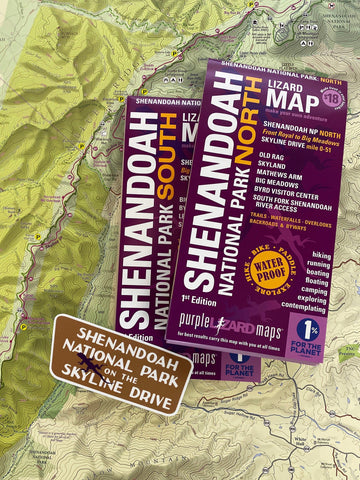


Purple Lizard Map - VA - Shenandoah National Park North & South (2 map pack)
Shenandoah National Park and the surrounding area is truly one of the jewels of outdoor recreation in the United States and the Purple Lizard Maps are the best maps to help you see your options in detail and plan all your Shenandoah adventures. (This area is far too big and has way too many fantastic outdoor recreation choices to do it justice with one map - this 2 pack is at the perfect scale for your best adventure planning).
The Shenandoah National Park Two-Pack includes both the North and South Shenandoah NP Lizard Maps which cover the eastern Shenandoah Valley, South Fork of the Shenandoah River and surrounding mountains. It is the most comprehensive, detailed, high quality, easy to read topographic map available of this stunning landscape from Front Royal in the north to Waynesboro and Crozet in the south, including the National Park, South Fork Shenandoah River, Page Valley, Shenandoah Valley and portions of the George Washington National Forest to the west. It includes the towns of Front Royal, Luray, Sperryville, Shenandoah, Elkton, Madison, Grottoes, Waynesboro and Crozet, Virginia.
-
SHENANDOAH VALLEY FROM FRONT ROYAL TO WAYNESBORO AND CROZET
-
ALL 105 MILES OF SKYLINE DRIVE AND THE OVERLOOKS
-
THE APPALACHIAN TRAIL AND PATC SHELTERS
-
SOME OF THE BEST HIKING TRAILS IN THE EASTERN UNITED STATES
-
WATERFALLS AND VISTAS
-
SHENANDOAH VALLEY AND SOUTH FORK OF THE SHENANDOAH RIVER
-
BACKROADS AND BYWAYS
-
NATIONAL PARK CAMPGROUNDS AND PICNIC AREAS
Public land: over 200,000 acres of Shenandoah National ParkForest and NPS Wilderness Areas, plus parts of George Washington and Jefferson National Forest, as well as Shenandoah River State Park, Virginia Wildlife Management Areas, Virginia Department of Wildlife Resource Land, Appalachian Trail Corridor Land and town parks.
Destinations: include Skyline Drive, the Appalachian Trail, Old Rag, and a tremendous amount of hiking trails in and around Shenandoah National Park.
Roads: all Lizard Maps show which roads are paved, dirt/gravel or gated administrative forest roads. Perfect for anyone looking to put together a remote route using backroads and byways.
Major hiking trails: the Appalachian Trail in its entirety as it traverses Shenandoah National Park. The Tuscarora Trail from it's Southern origin with the AT west to George Washington and Jefferson National Forest. The entire hiking trail network of Shenandoah NP. Portions of the northern section of the Massanutten Mountain National Recreation Trail in the George Washington and Jefferson National Forest.
Major biking trails: There are no mountain bike trails in Shenandoah National Park. There are shared use trails open to mountain biking in the George Washington and Jefferson National Forest.
Even more trails: Lizard Maps highlight and designate public trails and paths including hiking, biking, equestrian and rail trails managed by federal, state and local authorities. For paddlers, the South River at Waynesboro is shown, and the entire South Fork of the Shenandoah River from Grottoes to Front Royal, including mile markers 1-44 along the most popular access stretch.
Points of interest: National Park Service campgrounds, picnic areas, scenic overlooks, waterfalls, observation towers, climbing areas and lizard spots.
Towns: Front Royal, Luray, Sperryville, Shenandoah, Elkton, Madison, Grottoes, Waynesboro and Crozet, VA.
Lizards! The little purple Lizards you’ll find scattered on the map signify an interesting spot to check out. The Legend says “This Could Mean Anything: cool place, sweet view, local legend”.
Shenandoah National Park and the surrounding area is one of the best outdoor recreation playgrounds in the United States. Get the Lizard Maps and make your own adventure!